Teno vs Anaga vs Teide: Which Tenerife Hiking Region is Right for You?
I've guided groups through all three of Tenerife's major hiking regions, Teide, Anaga, and Teno, for 12 years. And I've seen the same mistake over and over: people book a single hike based on a photo, then realise they're in the wrong terrain, wrong climate, or wrong permit system. So let me cut through the noise. If you only have one day, do Teide. If you have two days, do Anaga on day two. If you have three, Teno will change how you see the island. .
I Did All Three Regions, Here's What Nobody Tells You
Most travellers land in Tenerife thinking it's one big volcanic island with one kind of hike. Wrong. Teide is a high-altitude alpine environment above the clouds. Anaga is a prehistoric laurel forest that feels like Jurassic Park. Teno is rugged coastal terrain where the Atlantic crashes against cliffs that drop 600 metres straight down. I've done all three in a single day, started at 5 AM on Teide, drove to Anaga by lunch, and finished in Teno by sunset. It's possible, but I don't recommend it unless you're chasing a challenge. Each region demands a different mindset.
Let me break down what nobody tells you in those glossy blog posts.
The Teide Experience
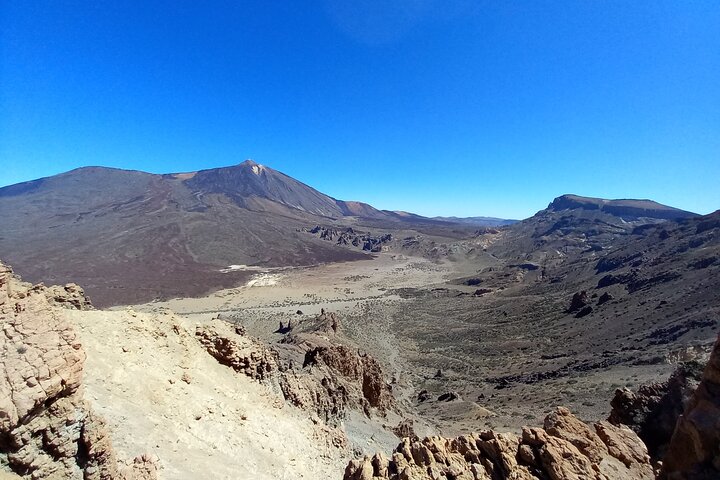
Teide at 3,715 metres is Spain's highest peak. The cable car gets you to 3,555 metres for about €38 return, but the real magic is the summit permit, free, but only 200 issued per day at 9 AM online. I've watched people book flights, rent cars, drive to the cable car station, and then realise they can't go beyond the crater rim without that permit. It's brutal. I always tell clients: check the Teide webcam before driving up. If the summit is clouded, you won't see anything anyway.
I booked the Teide Sunrise Hike and Breakfast Experience last spring with a group of eight. We started at 3 AM from the cable car station with head torches. The climb to the summit in the dark is surreal, you can see the lights of Los Cristianos twinkling below. At the top, the sun rises over Gran Canaria in the distance. The temperature was -5°C at 6 AM. Pack a proper jacket, not a hoodie.
Who it's NOT for: Anyone who hates planning ahead, has altitude sensitivity, or wants a relaxed morning. Teide demands permits, early starts, and warm layers.
Teide Sunrise Hike and Breakfast Experience
The best way to see the summit without stressing over permits, your guide handles the paperwork. The breakfast at the refuge is simple but welcome after the cold climb.
Book on Viator →Photo Gallery
Why Anaga Nearly Won Me Over
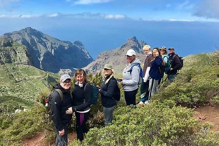
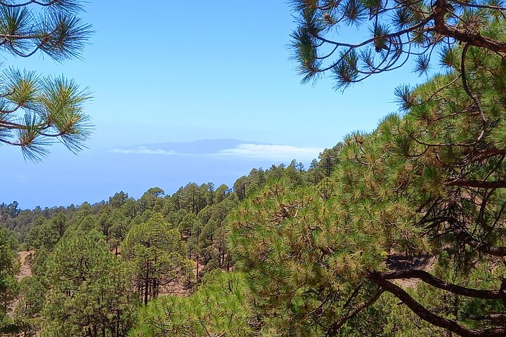
If I'm honest with you, Anaga is the region I send my friends to. It's the least hyped and the most rewarding for the effort. The altitude ranges from 200 to 1,024 metres, so you never feel the thin air or the cold. The laurel forest is a relic from the Tertiary , these trees have been growing here for millions of years. The trails are shaded, humid, and quiet. No permit needed for most routes, except El Pijaral which limits to 25 people per day.
I guided a family of four through the Anaga Mountains hiking trails last December. The kids were 8 and 11, and they ran ahead through the tunnel of ferns. We stopped at the Mirador de Aguaide for a view of the coastline that looks like the Azores. There's a bar at the trailhead that sells fresh orange juice and local cheese. It's the kind of day that makes you forget you're on a volcanic island.
I also tried the Anaga Mountains Guided Hike and Tapas Lunch with a solo traveller last month. The guide knew every plant by its Latin name and pointed out the endemic lizards that only live in Anaga. The tapas lunch was at a finca, local wine, goat cheese, and mojo sauce. It felt like a secret.
Who it's NOT for: People who want dramatic volcanic landscapes or high-altitude views. Anaga is green, misty, and intimate, not the postcard Tenerife.
Anaga Mountains Guided Hike and Tapas Lunch
Great for solo travellers or families who want local knowledge without the hassle of navigation. The tapas lunch is the highlight, proper Canarian food, not tourist fare.
The Teno Wild Card
Teno is the region that surprises people. Altitude from sea level to 1,342 metres, with trails that go from coastal paths to mountain ridges. The Masca Gorge is the famous one, a steep descent through a ravine to a beach. But you need a guide or a permit now, and the path is exposed with no shade. I've done it three times, and every time I see people in flip-flops and carrying one water bottle. They turn back after 20 minutes.
The coastal paths in Teno are what I recommend instead. The trail from Punta de Teno to Los Gigantes follows the cliff edge with views of the Atlantic. There's no shade, so start before 8 AM. I once guided a group of photographers there, and we spent two hours just watching the waves crash against the basalt columns. It's raw, wild, and empty.
Who it's NOT for: Casual walkers, people who dislike exposed paths, or anyone without sturdy footwear. Teno is for adventurers who don't mind a bit of risk.
The Moment I Made My Decision
After 12 years of guiding, I've settled on a hierarchy. If you're a first-time visitor to Tenerife, do Teide. It's the showstopper, the highest peak in Spain, the lunar situation, the cable car. But if you've already done Teide or you're returning, go to Anaga. It's the region I'd choose for my last hike on the island. Teno is the wild card, I recommend it only to experienced hikers who want to see the raw coastline.
Here's a decision table I use with my groups:
| Factor | Teide | Anaga | Teno |
|---|---|---|---|
| Altitude | 2,000–3,715m | 200–1,024m | 0–1,342m |
| Permit needed? | Yes (summit, 200/day) | Only El Pijaral (25/day) | Masca Gorge requires guide |
| Best for | First-timers, views | Nature lovers, families | Adventurers, photographers |
| Shade | None above tree line | Laurel forest canopy | Minimal on coast |
| Difficulty | Moderate-hard (altitude) | Easy-moderate | Moderate-hard (exposure) |
If you're still unsure, think about your fitness level and what you want to see. Teide is about the achievement. Anaga is about the immersion. Teno is about the edge.
What I Wish I'd Known Before I Went
I've made every mistake you can make in these regions. Let me save you the trouble.
- Teide cable car closes in high wind. Check the webcam before you drive an hour from the coast. I've had clients book the cable car, drive up, and find it closed. The wind at 3,500 metres is unpredictable even in summer.
- The cold at Teide is no joke. I've seen people in shorts and t-shirts at the cable car station. At 3,555 metres, the temperature can drop to -10°C even in July. Bring a down jacket, gloves, and a hat.
- Anaga gets fog by midday. Start your hike by 8 AM to see the views. By noon, the cloud rolls in and you can't see 20 metres ahead. It's atmospheric but frustrating if you want photos.
- Teno has no water sources. The coastal trails are dry. Carry at least 2 litres per person. I've seen people dehydrate on the Punta de Teno trail in summer.
- Book tours early. The best guides fill up weeks in advance, especially for Teide sunrise hikes. I've turned away groups because I was fully booked.
One more thing: don't try to do all three in one day unless you're a seasoned hiker with a support driver. I did it once for a challenge, and I was exhausted for two days after. Pick one region and explore it properly. You'll thank me later.
Last updated: June 2026
Explore More
Related comparisons and guides:
Frequently Asked Questions
Do I need a permit to hike Teide?
Only if you want to go beyond the crater rim to the summit. The free permit is issued online at 9 AM daily, limited to 200 people. The cable car takes you to 3,555 metres without a permit, but you can't climb the final 160 metres.
Which region is best for beginners?
Anaga. The trails are shaded, well-marked, and relatively flat. The altitude is low, so no risk of altitude sickness. Start with the trail from Chamorga to El Draguillo for an easy 2-hour walk.
Can I visit Teno, Anaga, and Teide in one day?
Yes, but I don't recommend it. You'd need to start at 5 AM on Teide, drive 90 minutes to Anaga by lunch, and another hour to Teno by sunset. You'll spend more time driving than hiking. Pick one.
What's the best time of year for hiking in Tenerife?
Spring (March to May) and autumn (September to November). The weather is mild, trails are less crowded, and the vegetation is green. Summer is hot on the coast, and winter can be cold at altitude.
Do I need a guide for Masca Gorge?
Since 2022, yes. You need a permit or a guided tour. The trail is steep and exposed, and rescues have increased. A guide ensures safety and handles the paperwork.
Which region has the best views?
Teide, hands down. The view from the summit at sunrise is unmatched, you can see all of Tenerife plus La Gomera, El Hierro, and Gran Canaria on a clear day. Anaga has intimate forest views, and Teno has dramatic coastal cliffs.